CV
Publications
Projects
Lectures
Research
Locations
Miscellaneous
Links
Events
News
Contact
NE-Thailand (Isan)
Research areas: Germany, Laos, Thailand, VietnamExcursions: Australia, China, Germany, Hungary, Morocco, Thailand (NE-part)
Introduction
The following
section is based on own impressions gained during field trips and on
information provided by literature and local museums.
In general, NE-Thailand consists of the Khorat plateau and adjacent mountain ranges with the Petchabun Mountains (as part of the Loei fold belt) in the west, the Sangkambeng Mountains in the southwest and the Phnom Dangrek Mountains in the south. The Mekong river is bordering the area in the north and the east. Within this plateau isolated inselbergs and inselberg ranges exist. The Phu Phan Mountains subdivide the Khorat plateau in the Sakhon Nakhon Basin in the north and the Khorat basin in the south. The first basin is directly drained in the Mekong River. The second is drained via the Chi River and Mun River in the Mekong River.
In general, NE-Thailand consists of the Khorat plateau and adjacent mountain ranges with the Petchabun Mountains (as part of the Loei fold belt) in the west, the Sangkambeng Mountains in the southwest and the Phnom Dangrek Mountains in the south. The Mekong river is bordering the area in the north and the east. Within this plateau isolated inselbergs and inselberg ranges exist. The Phu Phan Mountains subdivide the Khorat plateau in the Sakhon Nakhon Basin in the north and the Khorat basin in the south. The first basin is directly drained in the Mekong River. The second is drained via the Chi River and Mun River in the Mekong River.
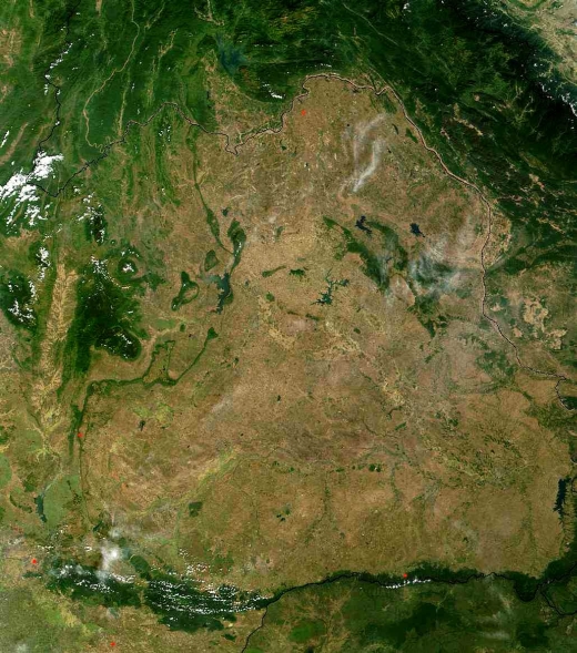
NASA satellite image of NE-Thailand (February, 2005).
Climate
The
Khorat plateau is dominated by a monsoonal, seasonally humid tropical
climate and belongs to the Köppen climate zone "Caw" [C =
humid
mesothermal; aw = dry winter] (Köppen 1923, Landon 1991). For the
western Khorat plateau, Pfeffer and Yongvanit (2006) calculated water
shortage until the monsoon season starts (May/June), whereas during the
entire rainy season humid to perhumid conditions exist, leading to a
high surplus of water.
Geology
From
the Paleozoic until to the Upper Jurassic, the region of modern-day
Thailand was characterized by the drifting of terranes with relicts of
Pre-Cambrian orogeny belts, their collision, and their melding into the
European-Chinese plate. A Variscian orogeny, the Yunnan Malay Mobile
Belt formed between the cratonal blocks. This zone was folded in the
following indo-sino and alpidic orogenesis. The north-south running
structures of the grabens and faults were already set up during the
Variscian orogeny, which were intensified during later orogenesis. In
the course of isostatic equilibrium movements of the crust, a
sedimentation area formed that covered all of the micro-continents and
deposited over 4500 m thick sediments of the Khorat Group (Triassic
-Cretaceous). This sedimentation ended with the start of new
tectonic activity in the Upper Cretaceous.
The collision of the Indian-Australian plate with the European-Chinese content lead to folding in the area of the Yunnan Malaien Fold Belt and then to two upheaval phases. The first upheaval phase was in the Oligo-Miocene, in which larger and also smaller grabens with sediments that can be dated and intramontane basins formed. A strong and fast upheaval phase at the boundary Pliocene-Pleistocene created the present orography of Thailand (Pfeffer and Yongvanit, 2006).
The oldest rocks (Paleozoic rocks) occur in the Loei fold belt in the northwestern part of NE-Thailand.
They comprise limestone (Devonian), sandstone, shale, graywacke and conglomerate (Carboniferous), limestone, shale, sandstone (Permian) (Salyaphongse et al., 1980). The thick, Fusulina bearing Permian limestone was formed in a shallow ocean between the different terrains. These limestone deposits are covered with younger Permian clay slates and sandstones (Pfeffer and Yongvanit, 2006).
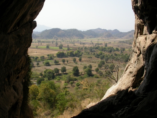
Perspective through the entrance of Phu Pha Man cave, which developed in Permian limestone, showing an embayment of the Khorat peneplain in karst mountains of Permian limestone in Khon Kaen province, Phu Pha Man district. Photo: U. Schuler, 2006.
The collision of the Indian-Australian plate with the European-Chinese content lead to folding in the area of the Yunnan Malaien Fold Belt and then to two upheaval phases. The first upheaval phase was in the Oligo-Miocene, in which larger and also smaller grabens with sediments that can be dated and intramontane basins formed. A strong and fast upheaval phase at the boundary Pliocene-Pleistocene created the present orography of Thailand (Pfeffer and Yongvanit, 2006).
The oldest rocks (Paleozoic rocks) occur in the Loei fold belt in the northwestern part of NE-Thailand.
They comprise limestone (Devonian), sandstone, shale, graywacke and conglomerate (Carboniferous), limestone, shale, sandstone (Permian) (Salyaphongse et al., 1980). The thick, Fusulina bearing Permian limestone was formed in a shallow ocean between the different terrains. These limestone deposits are covered with younger Permian clay slates and sandstones (Pfeffer and Yongvanit, 2006).
Perspective through the entrance of Phu Pha Man cave, which developed in Permian limestone, showing an embayment of the Khorat peneplain in karst mountains of Permian limestone in Khon Kaen province, Phu Pha Man district. Photo: U. Schuler, 2006.
Triassic rocks
occur mostly in the western part of the Khorat plateau and can be
allocated to two formations. The older Huai Hin Lat Formation consists
of gray to dark gray shale, sandstone, limestone and basal
conglomerate. The younger Nam Phong Formation consists of reddish-brown
sandstone; conglomerate; reddish-brown to brown siltstone and shale (Salyaphongse
et al., 1980).
During the Triassic period, the NE-Thailand has been covered by sea, followed by orogenesis (including volcanic activities) and uplifting of the Yunnan Malaien fold Belt, and subsidence of the Khorat plateau forming alluvial plains and lakes. These lakes contained algae, fishes, turtles and reptiles. Dinosaurs, prosauropod and sauropod began to appear, the earliest sauropod was Isanosaurus attavipatchi (Sirindhorn Museum - DMR, Kalasin province, 2011).
Jurassic rocks occur in the western, southern and central part of the Khorat plateau. The rocks can be allocated to three rock formations, namely to the Phu Kradung Formation (oldest formation), Phra Wihan Formation and the Sao Khua Formation (youngest formation ranging from Late Jurassic until Early Cretaceous). The Phu Kradung Formation consists of red and purple, calcareous and micaceous siltstone, sandstone and local basal conglomerate (Salyaphongse et al., 1980).
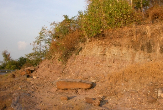
Siltstone and sandstone of the Phu Kradung Formation, in Khon Kaen province, Ban Fang district. Photo: U. Schuler, 2007.
The Phra Wihan Formation consists of white to purple red, cross bedded, thick bedded quartz sandstone, siltstone and claystone (Salyaphongse et al., 1980).
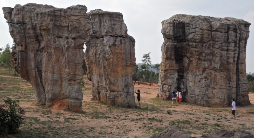
Sandstones pillars of the Phra Wihan Formation at the "Stonhenge of Thailand" in Chaiyaphum district, Chaiyaphum province. Photo: U. Schuler, 2011.
During the Triassic period, the NE-Thailand has been covered by sea, followed by orogenesis (including volcanic activities) and uplifting of the Yunnan Malaien fold Belt, and subsidence of the Khorat plateau forming alluvial plains and lakes. These lakes contained algae, fishes, turtles and reptiles. Dinosaurs, prosauropod and sauropod began to appear, the earliest sauropod was Isanosaurus attavipatchi (Sirindhorn Museum - DMR, Kalasin province, 2011).
Jurassic rocks occur in the western, southern and central part of the Khorat plateau. The rocks can be allocated to three rock formations, namely to the Phu Kradung Formation (oldest formation), Phra Wihan Formation and the Sao Khua Formation (youngest formation ranging from Late Jurassic until Early Cretaceous). The Phu Kradung Formation consists of red and purple, calcareous and micaceous siltstone, sandstone and local basal conglomerate (Salyaphongse et al., 1980).
Siltstone and sandstone of the Phu Kradung Formation, in Khon Kaen province, Ban Fang district. Photo: U. Schuler, 2007.
The Phra Wihan Formation consists of white to purple red, cross bedded, thick bedded quartz sandstone, siltstone and claystone (Salyaphongse et al., 1980).
Sandstones pillars of the Phra Wihan Formation at the "Stonhenge of Thailand" in Chaiyaphum district, Chaiyaphum province. Photo: U. Schuler, 2011.
In Jurassic,
the climate was hot and dry but many regions of northeastern Thailand
were still alluvial plains and swamps containing bivlaves,
fishes e.g. Lepidotes
buddhabutrensis, crocodiles (Sunosuchus
thailanddiscus). At
the same time dinosaurs began to evolve and increase in
population
such as sauropods, carnosaurs, hypsilophodons and stegosaurs
(Sirindhorn Museum - DMR, Kalasin province, 2011).
Cretaceous
rocks prevail in the basins of the Khorat plateau. The
period is
subdivided in four formations, namely the Sao Khua Formation (oldest
formation), Phu Phan Formation, Khok
Kruat Formation and the Maha Sarakham Formation
(youngest formation).
The Sao Khua Formation comprise purple, gray and red calcareous siltstone and sandstone (Salyaphongse et al., 1980).
Red calcareous siltstone of the Sao Khua Formation in the syncline NW of Phu Wiang, in Khon Kaen province, Phu Wiang district. Photo: U. Schuler, 2011.
The Phu Phan Formation consists of crossbedded, thick bedded sandstone; siltstone, and conglomeratic sandstone of variegated colors (gray, brown, orange, pink) (Salyaphongse et al., 1980).
Sandstone outcrop of the Phu Phan formation in the syncline NW of Phu Wiang, in Khon Kaen province, Phu Wiang district. Photo: U. Schuler, 2011.
The Khok Kruat
Formation consists of gray to pale red siltstone, sandstone
and
conglomerate (Salyaphongse et al., 1980).
During the transistion from Late Jurassic to Early Cretaceous northeastern Thailand became an extensive alluvial plain in which rivers from Vietnam, Laos and Cambodia joined in its central part before flowing to the sea further in the west. In this time, several dinosaurs species occurred, such as Phuwiangosaurus sirindhornae, Siamotyrannus isanensis, Compsognathus, Kinareemimus etc.. At later stage Iguanodon and Psittacosaurus sattayaraki evolved (Sirindhorn Museum - DMR, Kalasin province, 2011).
During the transistion from Late Jurassic to Early Cretaceous northeastern Thailand became an extensive alluvial plain in which rivers from Vietnam, Laos and Cambodia joined in its central part before flowing to the sea further in the west. In this time, several dinosaurs species occurred, such as Phuwiangosaurus sirindhornae, Siamotyrannus isanensis, Compsognathus, Kinareemimus etc.. At later stage Iguanodon and Psittacosaurus sattayaraki evolved (Sirindhorn Museum - DMR, Kalasin province, 2011).
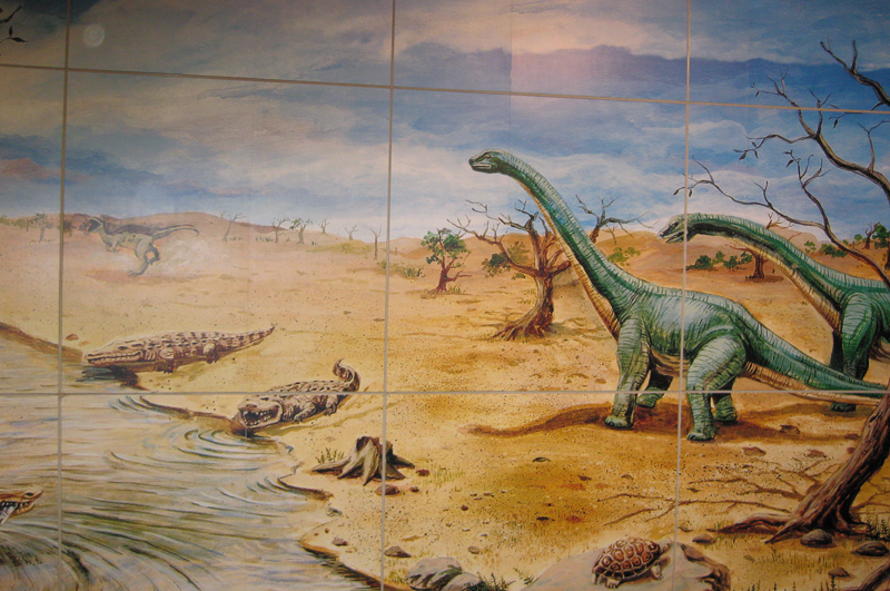
NE-Thailand during Early Cretaceous (as displayed in the Sirindhorn Museum).
The Maha Sarakham Formation
(Early Cretaceous) consists of reddish brown to
pale red siltstone and sandstone with frequent rock salt and gypsum (Salyaphongse
et al., 1980).
During the Late of Early Cretaceous, the Phu Phan mountain range was formed creating two landlocked basins, Sakhon Nakhon Basin in the north and Khorat basin in the south. In these basins, potash and rock salt deposits were formed in extreme salty lakes under arid climatic conditions, while some parts became desert. The dinosaurs have become extinct either prior to the dry land stage or during the desert forming stage (Sirindhorn Museum - DMR, Kalasin province, 2011).
With the begin of the Tertiary, an erosional period started creating large-scale peneplain formation, which goes through all of the geotectonic units. This also created large peneplains with laterite soils, inselbergs, -if hard sandstones, then mesas- and inselberg ranges in other parts of Thailand. This geomorphological phase ended with tectonic events in the Oligocene, when the collision of the Indian-Australian plate in Southeast Asia cause balancing movements and north-south running grabens formed and uplifting occurred. During this tectonic events the geotectonic units behaved differently and neighboring parts of the stable Khorat plateau were uplifted in several phases, leading to different peneplain levels (Pfeffer and Yongvanit, 2006).
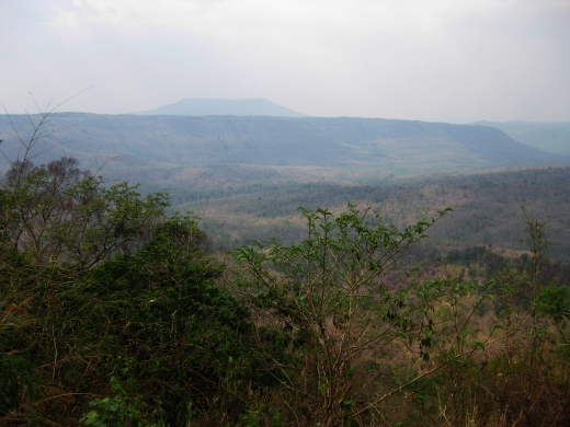
Cuesta
of Khorat sandstone, Petchbun peneplain (800-900 m asl), Phu
Dan
I Pong mesa (inselberg with table top - 1300 m asl), in Chaiyaphum
province, Khon San district. Before the uplifting started, the
Petchbun peneplain was connected with the Khorat peneplain (today at
around 300 m asl) (Pfeffer
and Yongvanit, 2006). Photo: U. Schuler, 2010.
During the Tertiary, the climate was hot and humid. Many different mammals lived in SE-Asia, e.g. primate, flying lemur, saber-toothed cat, rodent, suid and anthracoteres (Sirindhorn Museum - DMR, Kalasin province, 2011).
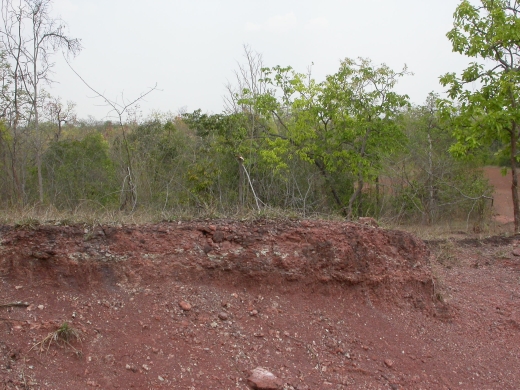
Quaternary rocks can be subdivided in older terrace deposits and younger alluvial deposits. The terrace deposits consist of gravel, sand, silt, plinthite (laterite) and plinthitic soils. The alluvial deposits consist of gravel, sand, silt and clay (Salyaphongse et al., 1980).
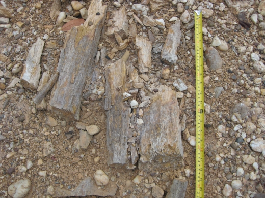
Quaternary fluvial gravel deposits with petrified wood in Khon Kaen province, Nong Rua district. Photo: U. Schuler, 2010.
For the Pleistocene epoch mammal fossils were discovered in many caves in Thailand. The exploration and research revealed many fossils of small rodent which are sensitive to the changing climate and environment. Fossils of giant panda and hyena were also found. These indicate the continuous change of climate and environment in Thailand 4-3 million years ago. The areas might have been alternative grassland and forest. In Late Middle Pleistocene about 200,000 years ago the climate became cooler and drier than present (Sirindhorn Museum - DMR, Kalasin province, 2011).
Tektites together with petrified wood, some of it with features of burning occur in terrace deposits in Khon Kaen province; and tektites found in sandy deposits within the Khorat peneplain give evidence to a severe asteroid impact in this region in "recent times". According to Paine (2001) such an impact occurred 800,000 years ago. Tektites related with this event can be found from China to Australia. Working on the geographic variation in tektite concentration Glass and Pizzuto (1994) estimated the diameter of the impact to be between 32 and 114 kilometers. They made no assertions about the impactor's characteristics. If it was a stony asteroid traveling at a speed of 22 km/s then its diameter would be between 2 and 5 km (Paine, 2001). It seems remarkable that such a large "fresh" crater has not been found but a comparison of known impact craters with the expected crater rate suggests that many ancient craters have not been found (Lewis, 1999). Potential locations of such a crater are supposed to be in the Mekong delta (Vietnam), or Tonle Sap lake (northern Cambodia), or in Laos (Paine, 2001).
During the Tertiary, the climate was hot and humid. Many different mammals lived in SE-Asia, e.g. primate, flying lemur, saber-toothed cat, rodent, suid and anthracoteres (Sirindhorn Museum - DMR, Kalasin province, 2011).
Quaternary rocks can be subdivided in older terrace deposits and younger alluvial deposits. The terrace deposits consist of gravel, sand, silt, plinthite (laterite) and plinthitic soils. The alluvial deposits consist of gravel, sand, silt and clay (Salyaphongse et al., 1980).
Quaternary fluvial gravel deposits with petrified wood in Khon Kaen province, Nong Rua district. Photo: U. Schuler, 2010.
For the Pleistocene epoch mammal fossils were discovered in many caves in Thailand. The exploration and research revealed many fossils of small rodent which are sensitive to the changing climate and environment. Fossils of giant panda and hyena were also found. These indicate the continuous change of climate and environment in Thailand 4-3 million years ago. The areas might have been alternative grassland and forest. In Late Middle Pleistocene about 200,000 years ago the climate became cooler and drier than present (Sirindhorn Museum - DMR, Kalasin province, 2011).
Tektites together with petrified wood, some of it with features of burning occur in terrace deposits in Khon Kaen province; and tektites found in sandy deposits within the Khorat peneplain give evidence to a severe asteroid impact in this region in "recent times". According to Paine (2001) such an impact occurred 800,000 years ago. Tektites related with this event can be found from China to Australia. Working on the geographic variation in tektite concentration Glass and Pizzuto (1994) estimated the diameter of the impact to be between 32 and 114 kilometers. They made no assertions about the impactor's characteristics. If it was a stony asteroid traveling at a speed of 22 km/s then its diameter would be between 2 and 5 km (Paine, 2001). It seems remarkable that such a large "fresh" crater has not been found but a comparison of known impact craters with the expected crater rate suggests that many ancient craters have not been found (Lewis, 1999). Potential locations of such a crater are supposed to be in the Mekong delta (Vietnam), or Tonle Sap lake (northern Cambodia), or in Laos (Paine, 2001).
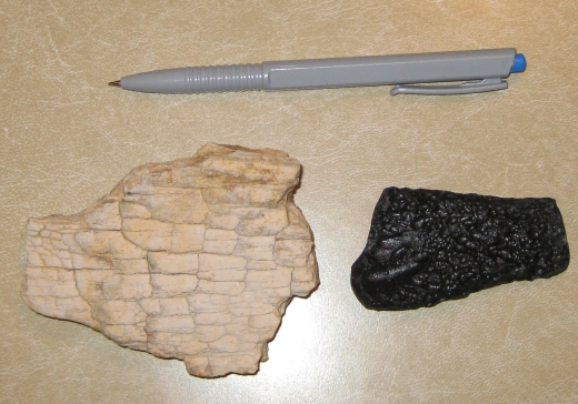
Petrified wood with features of burning (left), tektite (right) found in gravel pit in terrace deposits in Khon Kaen province, Nong Rua district. Photo: U. Schuler, 2010.
Soils
The major soils of NE-Thailand are Anthrosols, Acrisols, Cambisols, Plinthosols, Leptosols, and Solonchaks.
Anthrosols
Anthrosols are common in the Khorat peneplain, where paddy rice cultivation is or was practiced.
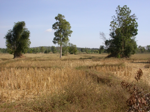 Typical
Anthrosol landscape with paddy rice cultivation, Khon Kaen province,
Nong Rua district. In the mountain range in the background
consists of sandstones belonging to the Phra Wihan Formation. Photo: U.
Schuler, 2007.
Typical
Anthrosol landscape with paddy rice cultivation, Khon Kaen province,
Nong Rua district. In the mountain range in the background
consists of sandstones belonging to the Phra Wihan Formation. Photo: U.
Schuler, 2007.Acrisols
Acrisols were described for the Petchbun Mountains. There, on slopes of ridges and mountain ridges formed by the rivers in the relief with outcropping shales, clays, siltstones and thinly bedded sandstones as well as on the peneplains intermediate level show clay translocation. The upper sections of the topsoils are sandy-loamy and have clearly higher clay contents in the B-Horizon, which showed clearly lower nutrient supply than the topsoil and had a very acidic pH value (Pfeffer and Yongvanit, 2006).
Cambisols
Cambisols were described for slopes of limestone karst hills (Pfeffer and Yongvanit, 2006).
Plinthosols
Plinthosols are common on the Khorat- and Petchabun peneplain. Generally, these soils have a only few centimeter thick topsoil of light color or sallow (Albic horizon), with a transition another 30-50 cm layer of fine sandy-silty topsoil. At the bottom of this layer were several gravel pieces and pisolithes with up to half centimeter diameter. These form a plinthite horizon, which were always several decimeters thick. On the Khorat peneplain, this horizon was at times denser and more hardened and up to over one meter thick pisolite layers could be observed locally. Under the plinthite horizon there was a red, sandy clayey loam with sesquioxides enrichments. In the upper section no structures could be recognized, whereas the deeper-reaching exposures sometimes below 1-2m under the surface of sandstones and shales, the outcrops show a ground hump structure. However, the rocks were pedogenetically reworked and have lost their rock hardness. Sometimes large grikes could be recognized in the limestones or ground humps of fresh rock, which were covered with initial solution marks. Deep exposures, trenches made for ponds, water reservoirs in ditches and street exposures showed that with depth, a stronger red-white mottling was present with full banding and several nests of clayey sections with gray-white color. The lowest exposure shows rock bleaching. Fresh rock could not be found until 6-15m (Pfeffer and Yongvanit, 2006).
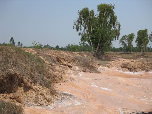
Pisolithic Plinthosols (Albic) developed from fluvial deposits, bearing fossil wood with features of burning and tektites give evidence of soil formation within the last 800,000 years - supposed both tektites and petrified wood fit to the impact event as described by Paine (2001).
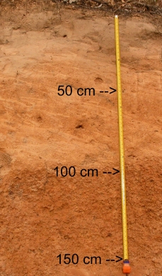
Pisoplinthic Plinthosol (Albic). Photo: U. Schuler, 2010.
The radioelement signature of the Albic horizon (0-94 cm soil depth) of these Plithosols showed very low concentratrations of K and low concentrations of eU and eTh. The following Pisolithic horizon (94-159 cm soil depth) showed slight, strong and very strong enrichments of K, eU and eTh respectively. The undelying parent material (fluvial gravel) revealed again low radioelement signatures.
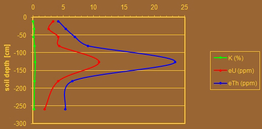
Radioelement signatures of a Pisolithic Plithosol (Albic).
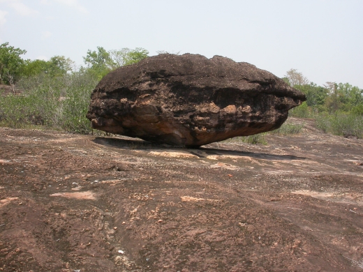
Leptosols
Leptosols are widespread in the area of the inselbergs and inselberg ranges, especial when they consist of limestone or quartz-rich sandstone.
Solonchaks
Solonchaks occur in the area of the Maha Sarakham Formation, which frequently contains salt and gypsum. In order to cultivate paddy rice, irrigation with salt-free water is required to reduce the high salt concentrations.
Solonchaks with salt crusts derived from the Maha Sarakham Formation in Khon Kaen province, Nong Rua district. Photo: U. Schuler, 2010.
References
Glass, B.P., Pizzuto, J.E., 1994. Geographic variation in Australasian microtektite conentrations: Implications concerning the location and size of the source crater. J. of Geophysical Research, 99, No. E9, 19075-19081, Sept. 1994 (abstract only).
Lewis, J.S., 1999. Comet and asteroid impact hazards on a populated Earth, Academic Press. Includes impact simulation software.
Paine, M., 2001. Signs of a devastating asteroid impact in Indochina 800,000 years ago.
Pfeffer, K.-H., Yongvanit, S., 2006. The karst region Khon San in Northeast Thailand. Z. Geomorph. N.F., 147, 77-106.
Phu Wiang Dinosaur Museum - DMR, Phu Wiang province, 2010. Public infomation.
Salyaphongse, S., Jungyusuk, N., Sattayarak, N., Suteethorn, V., Veeraburus, M., 1980. Geological Map of Thailand. Northeastern sheet. 1:500,000 scale.
Sirindhorn Museum - DMR, Kalasin province, 2011. Public information.
Wikipedia: NASA satellite image of NE-Thailand. Link: http://en.wikipedia.org/wiki/File:Isansatellite.jpg