CV
Publications
Projects
Lectures
Research
Locations
Miscellaneous
Links
Events
News
Contact
Research area: Thailand
Research areas: Germany, Laos, Thailand, VietnamResearch sites in NW Thailand: Bor Krai, Huai Bong, Mae Sa Mai
Bor Krai (Mae Hong Son Province)
The Bor Krai karst area is in Pang Ma Pha district, Mae Hong Son province, and covers 8.5km2. It extends from N 19° 32’ 41’’ to 34’ 10’’ and from E 98° 11’ 38’’ to 14’ 20’’.Map of the Bor Krai research area. Full extend.
The elevation ranges from 550m to 1020m asl with a mean elevation of 810m asl. The lowest point is located in a deep karst depression at the northern boundary of the area. The highest points belong to a mountain chain of limestone in the western part. According to the geological map of Northern Thailand at a scale of 1:250,000 (German Geological Mission, 1979), the petrography of the area consists to 100% of Permian limestone. Own investigations revealed that the area consists in petrographic terms of 60% limestone and 39% claystone, siltstone, and sandstone. The remaining 1% comprises alluvial deposits, dolomite, freshwater limestone, iron ore, and latite. Climatic measurements for 2004 and 2005 at 800m asl show a mean precipitation of 1197mm and a mean temperature of 19.8°C. During December, the night temperature sometimes drops below 5°C. The western and eastern parts of the area are characterised by steep, often cone-shaped mountains, consisting of mostly massive limestone with karst depressions in between. In the central part of the area smooth hills prevail. The forest consists of deciduous dipterocarp trees and bamboo, covering approximately 60% of the whole area. Human activities can be traced back to 9,000 to 12,500 years ago. For this time, the first human burials in Pang Ma Pha were reported (Sidisunthorn et al. 2006).
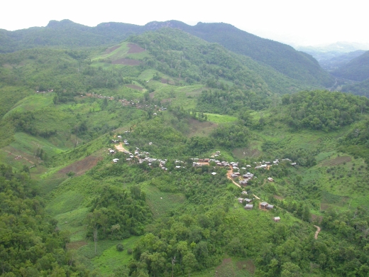
Bird view of Bor Krai village.
Soil mapping revealed the soil variety of the Bor Krai area as 66% Alisols, 20% Acrisols, 8% Cambisols, and 1% Leptosols Umbrisols, Ferralsols, Chernozems, and single rock outcrops each representing less than 0.1% (see soil map below).
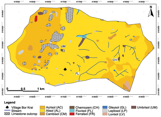
Soil map based on WRB 2006 for the Bor Krai karst area.